
Faden, William — Bernard Ratzer | First state of this important map of New Jersey, 1777
Lot closes
December 16, 03:16 PM GMT
Estimate
10,000 - 15,000 USD
Starting Bid
9,000 USD
We may charge or debit your saved payment method subject to the terms set out in our Conditions of Business for Buyers.
Read more.Lot Details
Description
Faden, William — Bernard Ratzer
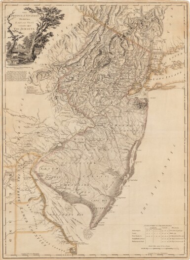
The Province of New Jersey, Divided into East and West, commonly called the Jerseys. London: Wm. Faden, December 1st, 1777
Engraved map (to sight: 806 x 578 mm), hand colored in outline, on 2 joined sheets; no visible defects, not examined out of frame.
The first state of one of the finest and most celebrated maps of New Jersey, made during the Revolutionary War.
This finely engraved map depicts New Jersey at a large scale of 7 miles to an inch. At the time of its publication, it was the largest and most detailed map of the state made up until that time. It includes the states topography, including the Jersey Highlands and the Palisades in the north and the broad Pine Barrens and coastal marshes in the south, as well as the county divisions, major roads and towns. The map also covers the Hudson Valley, most of Long Island, eastern Pennsylvania and all of Delaware Bay.
Faden, based in London, engraved his map based largely off the manuscript surveys of Bernard Ratzer, a British military surveyor best known for his map of New York City. Ratzer’s surveys of the state were produced to revolve a bitter boundary dispute that had persisted for a century between New Jersey and New York. George III, in 1764, enlisted Samuel Holland and William De Brahm with demarcating the boundary, and Ratzer was enlisted as the surveyor. This newly decided border is noted on the map as "The boundary settled by commissioners in 1769."
Another interesting feature on the map is the two lines bisecting the state, being the boundary lines between the earlier colonies of East and West Jersey. These boundaries were formed because, in 1664, after Charles II granted the New Jersey charter jointly to Lord Berkeley and Sir George Carteret, Berkeley sold his share to John Fenwick who passed it on to a consortium that included William Penn. In 1676, the king only renewed Carteret’s charter, and the already small province was split into two awkward colonies. One of the boundaries, "Keith's Line," refers to the 1687 demarcation by surveyor George Keith. After the two colonies were reunited under a royal governor in 1702, land ownership questions predicated on the partition necessitated that an internal line of division persist, which was re-demarcated as the "Lawrence Line" in 1743.
The map’s cartouche features a pastoral scene with farmhouses and racoons. In the lower left corner, there is a table of astrological observations. This is an excellent example of an important map, attractively hand colored in outline.
REFERENCES
Guthorn, British Maps of the American Revolution 39; Degrees of Latitude 47; Schwartz & Ehrenberg, Mapping of America 193; Snyder, The Mapping of New Jersey 57-59


![Pieter Schenk | Nova totius Asiae tabula, Amsterdam, [c.1710]](https://dam.sothebys.com/dam/image/lot/b211afed-e8c5-48bd-ab4f-cf03887674db/primary/extra_small)


