
John Churchman | Magnetic atlas or variation chart, Philadelphia, 1790
Lot closes
December 11, 03:11 PM GMT
Estimate
20,000 - 30,000 GBP
Starting Bid
19,000 GBP
We may charge or debit your saved payment method subject to the terms set out in our Conditions of Business for Buyers.
Read more.Lot Details
Description
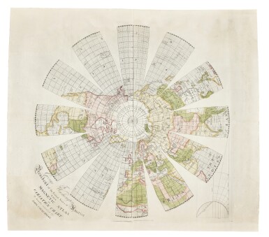
John Churchman
Magnetic Atlas or Variation Chart
Engraving (609 x 609mm.) with original wash colour, a few creases flattened, some areas of restoration to upper and lower sheet edges not affecting printed image
[together with:]
An Explanation of the Magnetic Atlas, or Variation Chart, hereunto annexed; projected on a plan entirely new. Philadelphia, 1790.
8vo, 2 folding charts, minor foxing to text, faint damp stain affecting portion of first four leaves, minor chips to edges
A PRESENTATION COPY, INSCRIBED BY THE AUTHOR TO GEORGE WASHINGTON, this work represents the last gasp for Edmund Halley’s theory for the determination of longitude by magnetic declination.
John Churchman (1753–1805) first came to prominence for his ‘Map of the Peninsula between Delaware & Chesapeak Bays’ (1778). In the mid-1780s, Churchman became consumed by the problem of finding longitude at sea, which had challenged navigators for centuries. He developed three basic premises: that the two magnetic poles could be located precisely, that on any meridian linking those poles magnetic variation was the same at every point, and that over the centuries the magnetic poles rotated at a constant rate around the geographic poles. If these premises were true, a mariner need know only his latitude and the local magnetic variation of the compass to ascertain his longitude with accuracy. Unfortunately for Churchman, his method was theoretically unsound, and practically flawed.
An aggressive self-promoter, Churchman communicated his method in both the United States and overseas to luminaries such as Benjamin Franklin, Thomas Jefferson, Joseph Banks, and learned bodies including the American Philosophical Society, the Royal Academy of Sciences (France), and the Board of Longitude itself. Responses to his work were somewhat mixed, with Thomas Jefferson, despite welcoming his work, raising practical objections. Despite even receiving strident criticisms, by 1790 Churchman had received enough encouragement from his correspondents that he published a remarkable map along with an explanatory pamphlet.
Due to its sheer size, the unusual projection, and the clarity and refinement of the engraving, the Magnetic Atlas is a most ambitious production for an American map of the period. It is extraordinarily rare, and the present example is remarkable in that the map appears to have been separately issued.
PROVENANCE:
Presented to the American Academy of Arts and Sciences by the Author, Cambridge MA, in 1791
LITERATURE:
ESTC W32217; Evans 22406 (pamphlet with map frontispiece); Phillips, p.1094 (pamphlet with map frontispiece); Sabin 13026; Wheat and Brun 6 and References 86 (pamphlet with map frontispiece; background on Churchman’s project and life from Charles H. Cotter, “John Churchman and the Longitude Problem”, Navigation 27 (1980) pp. 217-225; Phillip Lee Phillips, Virginia Cartography: A Bibliographical Description (Washington: Smithsonian Institute, 1896) pp.58-59; Margaret Beck Pritchard and Henry Taliaferro, Degrees of Latitude: Mapping Colonial America (New York: Harry N. Abrams, 2002) pp.232-235; Ben Smith and James Vining, American Geographers 1784-1812 (Westport: Praeger, 2003) pp.34-35


![Mendeleev, Dmitri Ivanovich | First edition of Osnovy khimii [Principles of Chemistry], with two early versions of the periodic table, St. Petersburg, 1869–1871](https://dam.sothebys.com/dam/image/lot/347ce25c-7614-4b4a-9cb7-e0a15dddd638/primary/extra_small)


