
Jacobsz | Pascaarte van alle de Zee-custen van Europa, Amsterdam, 1655
Lot closes
December 11, 02:34 PM GMT
Estimate
30,000 - 40,000 GBP
Starting Bid
26,000 GBP
We may charge or debit your saved payment method subject to the terms set out in our Conditions of Business for Buyers.
Read more.Lot Details
Description
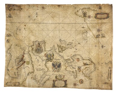
Anthonie Jacobsz
Pascaarte van alle de Zee-custen van Europa. Nieulijcx beschreven door Anthony Jacobszen. Amsterdam: op’t Water in den Jacobszen, 1655
Engraved hand-coloured chart on vellum (890 x 735mm.), slightly age-toned as usual, some finger soiling and staining to lower left, a few nicks and tears to margins
THE EARLIEST WORKING CHART TO DEPICT MAGNETIC VARIATION; AN EXCEEDINGLY RARE, SEPARATELY ISSUED, LARGE-FORMAT PLANE CHART OF EUROPE; only three other extant copies are known.
The chart depicts the entire European coastline and the shores of the Mediterranean. Oriented with the west towards the top, the chart assumes a Portolan-style appearance, with sparing geographic detail in the interior, but neat and tightly-clustered place names along the littoral. The seas are traversed by rhumblines, and embellished with ships and seals, while Inuit hunters, goats, bears, and elephants are depicted on the land. The interior areas are adorned with the elaborate national coats of arms of various nations, including Russia, Sweden, Denmark-Norway, the Holy Roman Empire, England, France, Spain and the Ottoman Empire. The chart is adorned with four scale cartouches, and a magnificent title cartouche.
The chart is almost a direct copy of Willem Blaeu’s chart of the same name, first published in the early 1620s. The present chart includes all Blaeu’s groundbreaking cartography, including the most detailed rendering of the Davis Strait and Greenland’s west coast to date; the omitting of the mythical island of ‘Friesland’; and the most advanced representation of Russia’s Arctic coastline. The one piece of extra geographical information added by Jacobsz is to the east coastline of Greenland, where the sightings of skipper Gaal Hamkes, "t Lant door Gaal Hamkes opgedaen in Jaer 1654", is marked.
LITERATURE:
Denucé, p. 8; Catalogue des cartes nautiques (1963), p. 313; Ristow, A la Cart, pp. 63–75; Schilder, Monumenta Cartographica Neerlandica, IV, 45.1; Schilder, Sailing Across the World’s Oceans, Jacobsz 1; Stopp & Langel, p. 33 and plate VI
![Pieter Schenk | Nova totius Asiae tabula, Amsterdam, [c.1710]](https://dam.sothebys.com/dam/image/lot/b211afed-e8c5-48bd-ab4f-cf03887674db/primary/extra_small)


![Mendeleev, Dmitri Ivanovich | First edition of Osnovy khimii [Principles of Chemistry], with two early versions of the periodic table, St. Petersburg, 1869–1871](https://dam.sothebys.com/dam/image/lot/347ce25c-7614-4b4a-9cb7-e0a15dddd638/primary/extra_small)
