
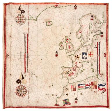
Illuminated Portolan Chart of Western Europe | by Dierick Vijt | Netherlands, probably Amsterdam | c.1575–1580
Lot closes
December 9, 02:13 PM GMT
Estimate
100,000 - 200,000 GBP
Starting Bid
90,000 GBP
We may charge or debit your saved payment method subject to the terms set out in our Conditions of Business for Buyers.
Read more.Lot Details
Description
Illuminated manuscript portolan chart in ink and colours on vellum, approximately 665 x 660mm., signed “Bij mij Dierick Vijt” by the western scale bar, the chart extending from Greenland to the west coast of the Kanin peninsula, including the north coast of Africa and the Mediterranean as far as Sardinia and Corsica, extending westwards to include the Canary Islands, the Azores, La Palma, Madeira, Porto Santo, the “phantom” island of Brasil, and an unidentified island off the west coast of Iceland, coastlines in green, the province of Holland outlined in red, coastal place names in red and black, sandbanks shown along the Dutch coast, 2 large and 5 small decorative compass roses, each border with a central half compass rose, 17 flags including of principal nations, two decorative scale bars and a longitudinal graticule, rhumb lines in red, green and gold, light soiling and creasing.
A VERY FINE SIGNED DUTCH PORTOLAN CHART BY DIERICK VIJT
PROVENANCE
1. Von Maldeghem family, probably Philippe von Maldeghem (1547–1611)
2. Sale, Christie’s, 1 June 1999, lot 9.
COMMENTARY
This Dutch Portolan chart contains one of the earliest representations of Northern Scandinavia, the White Sea, and the West coast of the Kanin Peninsula. In depicting the North Coast of Scandinavia as well as the White Sea, it firmly establishes this chart as an important addition to early Dutch cartography, elevating the North Holland school of mapmakers, akin to the Thames School, who dominated the great 16th-century expeditions to discover the North East Passage.
Interestingly, this map still shows the ‘ghost’ island of 'Brazil', while the coast of Greenland is reasonably well depicted, albeit lacking in detail. This is the only work known by Dierick Vijt and indicates that he likely had access to Portuguese or Spanish portolans, as the chart exhibits similarities in the decoration which appear to be modelled on the Catalan-style decoration found in Iberian charts, especially in the style of the compass roses, the flamboyant use of flags and shields, and the scale bars.
As northern Europe was not of vital importance to the trading interests of the Portuguese or the Spanish, Vijt had to draw on other sources for his mapping of Scandinavia, the White Sea, and the West coast of the Kanin Peninsula. He was likely familiar with the expeditions of Jenkinson and his four voyages to Russia between 1557-71, Stephen Borough’s expedition to the Lapland coast (in the Searchthrift in 1557), and Sir Hugh Willoughby to Nova Zembla and the White Sea.
This portolan is one of four charts previously in the possession of the von Maldeghem family, probably collected by Philippe von Maldeghem: a Portuguese chart by Luis Teixeira, dated 1578, a Thames School chart by Thomas Layton of Danzig, and an unsigned Dutch portolan of Western Europe of circa 1580. Philippe von Maldeghem (1547-1611) was a mayor of Bruges and served as courtier to Maximilian I, Elector of Bavaria, following in the footsteps of his father, who was chamberlain to Maximilian.
This Dutch Portolan chart contains one of the earliest representations of Northern Scandinavia, the White Sea, and the West coast of the Kanin Peninsula and is the only work attributable to Dierick Vijt.
LITERATURE
R. Pflederer, Census of Portolan Charts and Atlases, V058
FURTHER READING
Julio Rey Pastor & Ernesto García Camarero, La cartografía mallorquina. Madrid, 1960.
Heinrich Winter, “Petrus Roselli,” in Imago Mundi 9 (1952):1–11.
cf. Mitchell A. Codding, “Petrus Roselli, ‘The Mediterranean Sea, Black Sea, and Atlantic (Ireland to the Canary Islands,’ 1468” in Treasures from the Hispanic Society Library, ed. Codding & O’Neill. New York, 2021, no. 23.
You May Also Like


![Mendeleev, Dmitri Ivanovich | First edition of Osnovy khimii [Principles of Chemistry], with two early versions of the periodic table, St. Petersburg, 1869–1871](https://dam.sothebys.com/dam/image/lot/347ce25c-7614-4b4a-9cb7-e0a15dddd638/primary/extra_small)


