
The Cindy and Jay Pritzker Collection
Illuminated Portolan Chart of the Mediterranean | by Petrus Roselli | Spain, Mallorca | 1447
Lot closes
December 9, 02:14 PM GMT
Estimate
700,000 - 1,000,000 GBP
Starting Bid
600,000 GBP
We may charge or debit your saved payment method subject to the terms set out in our Conditions of Business for Buyers.
Read more.Lot Details
Description
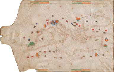
PETRUS ROSELLI (active, Palma de Mallorca, 1447–1469), illuminated Portolan chart of the Mediterranean World, including the Mediterranean and Black Seas, written in Latin and Catalan on a single very large membrane of vellum (22 x 37 inches, variable), drawn in brown ink with hundreds of place-names elegantly written in black or red in a small gothic book-hand, the coastlines lightly washed in green, small islands coloured in red, blue, green, or black, elaborately ruled from 16 loxodromic networks with rhumb-lines of red and green, emblazoned polychrome shields and flags of many countries, 9 city views drawn as fantastic coloured castles (blue, orange, green, and beige), most flying national flags, Andalusia depicted with huge green hills, 4 orange and green distance scales at upper and lower edges, signed and dated by Roselli on the western neck of the portolan, Pete. Rosell. La feta en malorqua en l ano Mccccxxxxvii [1447], written vertically so that it would be read from the west facing eastwards, nail holes at eastern edge, where the chart would have been secured for consultation.
A BEAUTIFUL PORTOLAN CHART, EARLIEST OF TEN NAVIGATION MAPS SIGNED BY PETRUS ROSELLI, THE MOST PROLIFIC MEMBER OF THE MALLORCAN SCHOOL OF CARTOGRAPHERS
PROVENANCE
1. The Martelli family of Florence, merchant princes who likely commissioned the chart from Petrus Roselli; descended in the Martelli archive for more than five centuries; sold, ca. 1968, to
2. Kenneth Nebenzahl, rare book and cartography dealer, Chicago; featured in his Catalog 20, Rare Americana (1968), item 164, described as coming “directly from the collection of Count Martelli in Florence,” sold, ca. 1968, to
3. Zinon C. Possis, Edina, Minnesota, sold, 1981, through the offices of Kenneth Nebenzahl, to
4. Cindy and Jay Pritzker, Chicago.
COMMENTARY
This beautiful portolan chart is the earliest of ten navigation maps signed by, or attributed to, Petrus Roselli, the most prolific member of the Mallorcan cartographic school. The Mallorcan school flourished from the thirteenth through fifteenth centuries on the largest of the Balearic Islands, an archipelago in the western Mediterranean Sea, near the eastern coast of the Iberian Peninsula. Mallorcan portolans characteristically include extensive details of cities (here including Barcelona, Venice, Jerusalem, Damascus, and Cairo), mountains, and rivers (the Nile, Dnister, Danube, Tiber, Arno, Rhone, and Guadalquivir); distinctive colouring of Mallorca (here striped in grey and black); heraldic flags denoting kingdoms (the flag at Istanbul is Byzantine, underscoring that the chart was drawn prior to 1453, when the city fell to the Ottomans; and a blue and white striped banner with a Star of David denotes Attalia, Turkey); and occasional text in vernacular Catalan as well as Latin (as with the cartographer’s inscription). The present map is so early in Roselli’s career that it does not feature the elaborate wind discs and compass roses that he used to embellish his later portolans. This early example also features the standard number of sixteen rhumb-lines, or loxodromes; it was Roselli who first increased that number to thirty-two, starting with his 1449 portolan, now in Badische Landesbibliothek, Karlsruhe.
Roselli was believed to be an Italian cartographer until Charles de La Roncière’s La découverte de l'Afrique au moyen âge: cartographes et explorateurs
Ro(Cairo, 1924) established that the name Roselli/Rossell could be traced back to the twelfth century among the converted Jews of Barcelona. Catalan Jews and conversos dominated the Mallorcan school until their expulsion from the Kingdom of Aragon at the end of the fifteenth century. Roselli may have been of Italian origin or not—for a time it was speculated that he might have been a pupil of the Genoese cartographer Battista Beccario—but for cartographical purposes he must be considered a Catalan. Catalan was also well known for the production of other aids to navigation and astronomy—and Roselli himself was a skilled compass-maker.Portolan charts, which appear to have originated in the late thirteenth century, as far as can be deduced from the documentary record and examination of surviving examples, gave a coastal configuration for the Mediterranean and Black seas of unparalleled accuracy for their time. Armando Cortesao believed that the ‘advent of the portolan chart … was one of the most important turning points in the whole history of cartography.’ Their contemporaries, the later medieval mappaemundi, display a view of the world that reflected theological concerns and was sometimes dominated by them. By contrast, the portolan charts encapsulate the Mediterranean seaman's intimate knowledge of his own world. Ironically, it was the charts’ exceptional usefulness to practical men that has left a comparatively small sample for study” (Campbell, 1986, p. 67).
The Pritzker portolan chart was unrecorded until it was rediscovered in the 1960s in the archive of the Martelli family in Florence, who likely commissioned it. The Martellis were influential Florentine merchant princes and rivals of the Medicis, until the families were united by the marriage of Camilla Martelli and Cosimo I de’ Medici, Grand Duke of Tuscany, in 1570.
This portolan was designed to be used on a ship: its scale is unusually large owing to the relatively limited geographic area covered and the large size of the parchment membrane. The chart embraces the entire shorelines of the Mediterranean and Black seas, including Spain, France, Italy, Greece, the Byzantine Empire, Egypt, and Northern Africa. Because Roselli’s portolans were custom-made for the client’s purpose and zone of interest, the one made for the Martellis omits the Atlantic and Baltic coasts, and most island and inland towns.
Although Roselli prepared this portolan as a practical navigational chart and not as an ornament for a nobleman’s library, because it remained in a single family for more than five centuries it survives in brilliant condition, remarkably bright and fresh.
Not only is the present example of the Mediterranean and Black seas the earliest recorded portolan by Roselli, only nineteen charts worldwide can be dated earlier and these are almost exclusively held by institutional collections. Only one other of Roselli’s ten charts has ever appeared at auction, a 1469 portolan of Europe, the Near East, and Africa deaccessioned by the Getty Museum and sold by Sotheby’s in 1988 for £165,000 ($300,000).
While the current location of the 1469 chart is not known, with the exception of the Pritzker example, all of Roselli’s other portolans are held by museums and libraries: Museo e biblioteca Guarnacciana, Volterra; Badische Landesbibliothek, Karlsruhe; Newberry Library, Chicago; Bibliotheque nationale, Paris; Germanisches Nationalmuseum, Nuremberg; British Library, London; James Ford Bell Library, University of Minnesota; and the Hispanic Society of America, New York.
THIS REPRESENTS PERHAPS A FINAL OPPORTUNITY TO ACQUIRE A SIGNED AND DATED PETRUS ROSELLI PORTOLAN CHART— OR, INDEED,
ANY PORTOLAN CHART—FROM THE FIRST HALF OF THE FIFTEENTH CENTURY.
LITERATURE
Campbell, Tony, “Census of Pre-Sixteenth-Century Portolan Charts,” in Imago Mundi 38 (1986):67–94.
Campbell, Tony , “Portolan Charts from the Late Thirteenth Century to 1500,” in The History of Cartography. Volume One: Cartography in Prehistoric, Ancient, and Medieval Europe and the Mediterranean, ed. Harley & Woodward. University of Chicago Press, 1987, pp. 371–463.
Llompart, Gabriel, “Registro de los cartógrafos medievales activos en el puerto de Mallorca,” in Anuario de Estudios Medievales 27.2 (1997):1117–1148.
Julio Rey Pastor & Ernesto García Camarero, La cartografía mallorquina. Madrid, 1960.
Winter, Heinrich, “Petrus Roselli,” in Imago Mundi 9 (1952):1–11.
cf. Mitchell A. Codding, “Petrus Roselli, ‘The Mediterranean Sea, Black Sea, and Atlantic (Ireland to the Canary Islands,’ 1468” in Treasures from the Hispanic Society Library, ed. Codding & O’Neill. New York, 2021, no. 23.
You May Also Like


![Pieter Schenk | Nova totius Asiae tabula, Amsterdam, [c.1710]](https://dam.sothebys.com/dam/image/lot/b211afed-e8c5-48bd-ab4f-cf03887674db/primary/extra_small)

