
Arrowsmith, Aaron | The most accurate representation of the West Indies and its environs
Lot closes
December 16, 03:04 PM GMT
Estimate
10,000 - 15,000 USD
Starting Bid
8,000 USD
We may charge or debit your saved payment method subject to the terms set out in our Conditions of Business for Buyers.
Read more.Lot Details
Description
Arrowsmith, Aaron
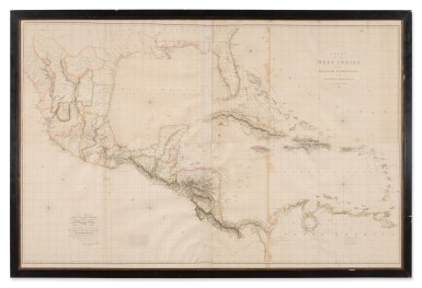
Chart of the West Indies and Spanish Dominions in North America. London: Jones, Smith, & Co., 1803
Large engraved wall map on four sheets, joined as two, with contemporary outline hand-coloring, to sight 12.25 x 190 cm, plate 122 x 189 cm; some staining along one vertical fold with old linen tape reinforcement on recto, with loss of a few letters, generally clean and fresh. Glazed and framed; unexamined out of frame.
The most accurate representation of the West Indies and its environs.
A handsome and authoritative large-format chart by Aaron Arrowsmith, the foremost British cartographer of his era. Centered on the Caribbean basin, the map covers the West Indies, the Gulf of Mexico, and the vast Spanish territories stretching from Florida and Louisiana to Central America and northern South America. Arrowsmith’s work is distinguished by its precision: coastlines are sharply rendered, soundings and shoals meticulously plotted, and navigational hazards clearly marked for mariners.
The chart reflects the geopolitical moment of the early nineteenth century, just prior to the transfer of Louisiana and amid shifting colonial claims across the Americas. Islands, ports, capes, and major waterways are given careful treatment, and the composition shows Arrowsmith’s characteristic balance of clarity and restraint. A strong example of a foundational map for the region—both a navigational tool and a record of imperial geography at a decisive point in Atlantic history.
The map focuses on the Caribbean and Mexico, extending from Mexico’s Pacific coast to the Leeward Islands, incorporating the whole of the Caribbean. At the time of publication, this monumental wall map was the most accurate survey of the region. Arrowsmith synthesized the best available information, most notably the pre-Revolutionary War surveys of John William Gerard De Brahm (Georgia), Bernard Romans (Florida), and the Spanish coastal surveys for Texas and the Gulf of Mexico. Streeter mentions one particular chart, the "Carta Esferica" of 1799—the first to name the bays of Galveston and Bernardo—from which Arrowsmith based much of the coastline, but notably with the longitude of the Sabine Pass greatly improved.
The dedicatee, John Willett Payne (1752–1803), was a British rear-admiral born on St. Kitts in the West Indies and seemingly the perfect recipient of Arrowsmith’s honor. In peacetime he became the private secretary, comptroller of the household, and personal friend of the Prince of Wales. DNB notes “There is no doubt that he was the associate of the prince in his vices and his supporter in his baser intrigues." In 1780 Payne became Member of Parliament for Huntingdon. Returning to the sea in 1793 he played a distinguished part in the battle of the “Glorious First of June,” 1794, for which he received the gold medal. In 1799 he was promoted to the rank of rear-admiral, and in August he was appointed treasurer of Greenwich Hospital, where he died.
Arrowsmith was the finest cartographer of his generation. Although he received little formal education it is believed that he was taught some mathematical instruction by William Emerson, author of several books on the application of mathematics to the area of cartography. Around 1770, Arrowsmith moved to London to seek employment. It is believed that he worked for William Faden before joining John Cary Sr. in the early 1780s. There he provided the measurements for John Cary’s early publication detailing the roads from London to Falmouth, his first signed work. Arrowsmith established his own practice in 1790 and over the next thirty years produced some of the most beautiful maps of the era.
REFERENCES
Stevens and Tree only list two editions, 1803 and 1810, but Phillips lists an 1811 and an 1816 edition


