
Gordon, William | The first full-scale history of the revolutionary war by an American
Lot closes
December 16, 03:19 PM GMT
Estimate
5,000 - 7,000 USD
Starting Bid
4,500 USD
We may charge or debit your saved payment method subject to the terms set out in our Conditions of Business for Buyers.
Read more.Lot Details
Description
Gordon, William
The History of the Rise, Progress, and Establishment, of the Independence of the United States of America: including an Account of the Late War; and of the Thirteen Colonies, from their origin to that period. London: Printed for the Author, 1788
4 vols., 8vo (210 x 125 mm). Complete with 9 engraved folding maps; some leaves foxed and toned, a few stray stains, maps with instances of offsetting, foxing, and marginal tears, hole to map 4, closed tears to maps 5 and 9. Contemporary tree calf, smooth spine in six compartments; rebacked to style retaining the original morocco gilt-lettered pieces to the second and fourth compartments, rubbing and chipping to extremities and spine labels, booklabel to upper pastedown of vol. 3 effaced.
A first edition set of the "first full-scale history of this war by an American; to its preparation Jefferson contributed some aid" (Howes).
William Gordon was a dissenting minister in England, who like many of his class sympathized with the contention of the Thirteen Colonies. He traveled to America during the disturbances and became pastor of the church at Jamaica Plain, now a district of Boston. Throughout the Revolution, he was a spectator to many significant events and developments and the associate of many of the chief patriots. He is “deservedly reckoned as the most impartial and reliable of the numerous historians of the American Revolution" (Sabin).
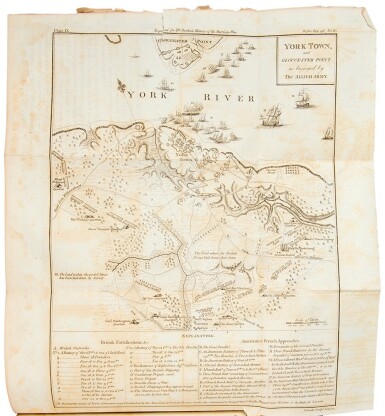
The work is noted for its folding maps, engraved by T. Conder, which include a general map of the United States, as well as maps of New England, New Jersey, Virginia, and the Carolinas, maps of the areas surrounding Boston and New York City, and battle plans of Fort Moultrie and Yorktown.
REFERENCES
Howes G256; Sabin 28011; Larned 134; Gephart 996; Revolutionary Hundred 86


