
Clark, Matthew | A rare map of the Long Island and Cape Cod coasts from the first American-made atlas
Lot Closed
June 26, 06:04 PM GMT
Estimate
35,000 - 45,000 USD
We may charge or debit your saved payment method subject to the terms set out in our Conditions of Business for Buyers.
Read more.Lot Details
Description
Clark, Matthew
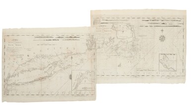
Chart of the Coast of America From [Ge]orge's Bank to Rhode Island including Nantucket Shoals &c. From the latest Surveys J. Norman Sc. Boston: Matthew Clark, 1790
Two sheets joined (approx.: 495 x 633 and 495 x 643 mm). Engraved map, tipped onto matboard; instance of offsetting, scattered foxing, one of two splits expertly repaired, small area of primarily marginal restoration.
"The first totally American production of its kind" (Garvan).
Following the American Revolution, the United States began to form a political identity within their newly-defined boundaries. American cartographers responded to this, taking control from their colonial forebearers regarding how these boundaries would be depicted. In 1790, Matthew Clark, a Boston merchant and auctioneer, published the country's very first atlas.
Clark's own business largely centered on West Indian goods. "Constantly on the docks and involved in coastal shipping, he saw the need for and had access to local navigational information" (Garvan). Partnering with engraver and print seller John Norman, Clark announced his intention in the 22 February 1790 issue of the Boston Gazette: "When so many attempts are making toward the advancing of the interests of the arts and manufactures in this Country—when the vast extent of sea coast on the American shores, and the numerous and dangerous rocks, shoals, &c. are considered, the utility of such a work will be readily admitted—more especially when there are so few charts of this coast extant, and those drawn on an inconsiderable scale." The charts referred to were those by Holland and Des Barres in The Atlantic Neptune, Thornton and Fisher in the fourth book of the English Pilot, and charts by Sayer and Bennett in the North American Pilot. The charts from those British works were largely unavailable to the New England ship captains who traded cargo up and down the east coast. Clark realized that the financial success of his atlas—the first to be made in America— would depend largely on whether or not the Yankee captains felt they could trust his charts. He therefore engaged Osgood Carleton, a noted Boston mathematician, and the Boston Marine Society, to endorse their accuracy.
Cartographically, Clark's charts are based on Des Barres' and others; however, they do contain significant additions drawn from local knowledge, leading Carleton to declare them as "more accurate than any before published." Carleton continued:
"as an adaptation for a specific purpose, these charts show a great deal of imagination and ability. Instead of simply compiling details or republishing old surveys, they increased the scale of the coastal areas. The water areas were restricted to a narrow coastal corridor with no references to distances to or from London or Europe" (Garvan).
In short, they were distinctly American, and their success was the catalyst for the birth of American cartography.
Clark's "charts" are extraordinarily rare, with only eight complete sets are known. "One of the most desirable rarities of American cartographic literature" (Bosse).
(See following lot.)
REFERENCES:
Bosse, "The World of Maps" in The American Magazine, Vol. 3., No. 1; ESTC W18996; Evans 21738; Garvan, "Matthew Clark's Charts One Significant Example of Yankee Enterprise," in Philadelphia Printmaking: American Prints before 1860, pp. 43-69; Guthorn, pp. 7, 43, 96; McCorkle, America Emergent 51; Phillips 3667; Ristow p. 224; Wheat and Brun 626, 627


![Gaston Migeon | Exposition des Arts Musulmans, Paris, [1903]](https://dam.sothebys.com/dam/image/lot/813fa454-1872-4b8a-85d4-81e82490ed18/primary/extra_small)


