
Benjamin Franklin | A separately issued, large paper copy of the Le Rouge edition of Franklin's map of the Gulf Stream
Live auction begins on:
June 24, 06:00 PM GMT
Estimate
20,000 - 30,000 USD
Bid
12,000 USD
Lot Details
Description
Benjamin Franklin
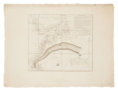
Remarques Sur la Navigation de Terre-Neuve à New-York afin d’éviter les Courrants et les bas-fonds au Sud de Nantuckett et du Banc de George. Paris: Le Rouge, circa 1782
Engraved map (sheet: 470 x 623 mm; platemark: 335 x 380 mm). Separately issued, large-paper copy, with full margins and deckle edges, a manuscript note on the verso: "Presented to the Congl. Library,/by Dr. Thos. Hewson Bache, Philadelphia"; minor dust-soiling, a miniscule ink stain, and few short tears along the edges, far from the printed surface, small pencil notation in lower right, a near pristine copy. Matted.
A fine copy of Franklin's second chart of the Gulf Stream, printed in Paris by George-Louis Le Rouge, offered here with full margins and an inscription on the verso from Dr. Thomas Hewson Bache, Franklin's great-great grandson.
The chart is both a scientific achievement and a diplomatic statement, asserting America's dominance over the Atlantic while suggesting a special relationship between the United States and her closest ally, France.
Benjamin Franklin's chart of the Gulf Stream was first printed in 1768 by Mount and Page in London while Franklin was serving as Deputy Postmaster General. It is the first map to depict the Gulf Stream's flow. Franklin observed the Stream as early as 1726 while travelling to England, though he did not understand what he had seen. Later, he also noted that a sea voyage from London to Boston was quicker than one from Falmouth to New York, and a trip from America to England was shorter than either of these. In a letter to Anthony Todd dated 29 October 1769, he first claimed that this phenomenon was due to the "Gulph Stream" (Papers of Benjamin Franklin, 15:246–247). Franklin knew that a clearer understanding of the Stream would be a useful tool, especially for his postal system.
In order to prove his hypothesis Franklin turned to his cousin Captain Timothy Folger, a mariner from Nantucket who was in London at the time. Folger claimed that Nantucket whalers had long followed and avoided the current, and that they would cruise along the Stream's edges while searching for whales. Folger provided Franklin with a chart of the Stream marked in red, as well as written instructions for navigating both in and around it, and for avoiding the dangerous shoals along its path. He also notes the speed of the Stream, and how it diminishes as the current flows away from America and widens. The map names both Franklin and Folger as its authors, a nearly unprecedented acknowledgement of a scientist and a mariner's close collaboration. The chart of the stream and Folger's navigational directions were engraved onto an existing plate—a four-sheet map of the Atlantic, now obsolete, that had originally appeared in the Atlas Maritimus Novus of 1702. Though copies of that map were distributed to mail-packet ship captains, there was little demand for them, and only three copies are now known to exist, all in institutions (Bibliothèque Nationale de France: 2 Copies; Library of Congress).
Franklin's second chart, published around 1782, is an original engraving, unlike the previous example that recycled an old copperplate. It is smaller than the Mount and Page version, focusing only on the North American coastline rather than the whole of the Atlantic. It reprints Folger's instructions, but translated clumsily into French. It does not mention Captain Folger by name. Franklin had disowned his cousin long before — the captain was an English loyalist, like many Nantucketers, and he had illicitly traded with the British while under Franklin's protection.
Franklin's hope for the Le Rouge map of the Gulf Stream was to increase and improve trade between France and the United States. As such, these maps were printed in limited numbers, intended for distribution among French ship captains. In 1783, Franklin gave a copy of Le Rouge's map to Michel Guillaume de Crèvecoeur, the director of U.S. affairs in the French Ministry of the Marine. Crèvecoeur had been charged with the creation of a packet-boat service between France and America. On that presentation copy, Franklin crossed out the poorly translated directions, rewrote them in the original English, and made a note about the water's temperature—a sign that Franklin had, in fact, conducted some of his own scientific research on the Gulf Stream. The temperature of the Gulf Stream's waters would be further studied by his grand-nephew, Jonathan Williams. Williams's book, Thermometrical Navigation (1793), would prove that mariners could measure the ocean's temperature to locate the Gulf Stream (see lot 150). Franklin would also produce a third edition of this map in 1786, published in an article in the Transactions of the American Philosophical Society (see lot 137 for a related, 1787 example).
Dr. Thomas Hewson Bache (1826–1912), was a prominent Philadelphia physician, a Civil War surgeon, the son of Dr. Franklin Bache, and the great-great grandson of Benjamin Franklin. Dr. Bache inscribed this copy to the Library of Congress. The provenance suggests that this is likely one of the copies that Franklin had kept for himself.
This is only the second copy of this map offered at auction in the last ten years, according to Rare Book Hub.
REFERENCES
Pritchard & Taliaferro, Degrees of Latitude, 62; Joyce E. Chaplin. The First Scientific American: Benjamin Franklin and the Pursuit of Genius, (2006) pp. 196–200, 289–292
PROVENANCE
Dr. Thomas Hewson Bache (presumably by descent from Benjamin Franklin) — The Library of Congress (presentation inscription; later deaccessioned)
You May Also Like


